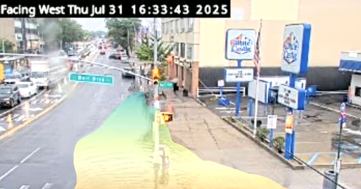
Flooding in urban areas is not just a nuisance; it’s a systemic hazard. Heavy rainfall, overwhelmed stormwater systems, blocked drains, rising rivers, and poor drainage all conspire to turn roads into rivers, inundate infrastructure, trap vehicles, and endanger lives. As climate change intensifies, these events are becoming more frequent, more sudden, and more damaging.
The Stakes: Real Examples, Real Costs
Some numbers and stories help ground the urgency:
- The remnants of Hurricane Ida triggered extreme rainfall and flash flooding across the northeastern U.S. In New York City, Ida produced a record hour of 3.47 inches (88.1 mm) in one hour at Central Park — the highest on record for that gauge. [1]
- As a result of Ida’s flooding in NYC, 11 people drowned in flooded basements and low-lying areas. [2]
- The USGS conducted a high-water mark survey in the five boroughs after Ida, documenting dozens of locations where debris lines, flood levels, and structural marks confirmed severe flash flooding. [3]
- In the Northeastern U.S., Ida is estimated to have caused $16 to $24 billion in flooding damage. [4]
Those are just a few snapshots. In urban environments, even modest water levels on roadways can disable vehicles, hamper emergency response, compromise bridges or underpasses, or cut off neighborhoods. Critical infrastructure—subway entrances, underground tunnels, drainage pumping stations, hospitals, mobility corridors—can be vulnerable.
Given the pace of extreme rain events, municipalities are beginning to ask: Can we detect flooding faster, more locally, and more reliably? Can we get ahead of the water rather than always reacting downstream?
Approaches Cities Are Using for Flood Detection
Below is a survey of modern strategies municipalities and agencies are trying, including strengths and complexities.
Traditional / Sensor-based Methods
- Gauge / water-level sensors
Vertical probes in stormwater drains, rivers, or basins measure water height. These are reliable but often sparse, limited to defined waterways or channels—not the road surface. - IoT / low-cost sensors
Some cities deploy low-cost water level sensors (e.g. ultrasonic, pressure-based) in storm drains, roadside gutters, or drains. The challenge: they generally monitor a single point and may not reflect how flooding spreads across road surfaces. - Rainfall modeling and hydrologic simulation
Using upstream precipitation data and watershed models, cities can simulate the likely progression of surface flooding. This can provide forecasts but is dependent on accurate models, calibration, and real-time data inputs. - Crowdsourced / citizen reports and emergency calls
Using 311 calls, social media, or crowdsourced trip reports (e.g. Waze) to detect flooding hotspots. This offers broad coverage but is reactive and often delayed. - Smart city/analytics + sensor fusion
Some municipalities combine weather forecasts, radar rainfall data, soil moisture sensors, and drainage system telemetry to build predictive insights.
Each method has trade-offs: point sensors may not reflect spatial spread; simulation models may struggle with micro-scale variability; crowdsourced data is delayed; and camera-based systems must handle changing lighting, occlusions, reflections, and calibration challenges.
However, video-based AI offers a strong complement. Cameras are typically already installed and maintained under municipal service contracts, which makes them far more cost-effective to enhance with new intelligence than deploying single-use sensors that require their own maintenance, networking, and support infrastructure. In addition to being highly scalable, cameras can act as a multi-sensory system—delivering both visual confirmation and analytical data—whereas many other sensors are limited to one function and lack the context of what’s actually happening on the ground.
ClearFlood: ClearVision for Flood Detection
At ClearObject, we extended our ClearVision platform to the domain of flood monitoring. We call this module ClearFlood. Its role: to ingest live video feeds (often from existing traffic, CCTV, or roadway cameras), interpret visual water signals, estimate flood geometry and risk thresholds, and dispatch alerts to response teams before conditions worsen.
How ClearFlood Works: From Pixels to Flood Insights
- Camera integration & calibration: ClearFlood connects to live video streams from existing road or surveillance cameras. For each camera, we perform calibration (intrinsic + extrinsic) and road-plane modeling so that image coordinates can be correlated with real-world ground plane geometry.
- Water detection & segmentation: Using deep learning and computer vision models, FloodVision classifies which pixels in the scene correspond to water, wet surfaces, or reflections. It segments flooded zones in each frame.
- Surface area & inundation mapping: After segmentation, it computes the area of flooding, bounding boxes, and shapes of inundated zones on the roadway or shoulder.
- Depth estimation (where feasible): If camera perspective and environmental cues (curbs, lane markings, slopes) allow, the system can estimate relative depth or water elevation, especially around landmarks or boundaries whose heights are known.
- Risk thresholding & alert logic: Operators or agencies can define thresholds (e.g. > 2 in of water, or more than X feet across a lane). When a threshold is crossed, FloodVision fires alerts in real time.
- Alerting & integration: Alerts can be pushed to a traffic management center, to first responders, via dashboards, or even to dynamic message signs (DMS) or variable signs on roadway approaches.
- Dashboard and analytics: All events are logged with metadata (time, location, flood footprint, estimated depth). GIS overlays, historical trends, hotspots, false alarm tracking, and reliability metrics are available in a user interface.
- Feedback loop & continuous learning: Over time, operator-verified events, corrections, and ground truth data feed back into the system. ClearFlood tunes its detection models, thresholds, and calibration parameters. The result: the system becomes more robust and accurate with experience.
Why ClearFlood Matters for Cities
- Leverage existing cameras: Because many roadways already carry CCTV or traffic cameras, FloodVision often avoids costly new sensor deployment.
- Spatial awareness of flooding: Unlike point sensors, FloodVision shows where flooding is happening, how big it is, and (optionally) how deep it is.
- Faster alerts, earlier response: Instead of waiting for reports or physically inspecting, FloodVision can detect water creep in early stages and push alerts proactively.
- Scalable and modular: Once an operational site is validated, the same underlying system can be extended to multiple intersections, corridors, drainage zones, or flood-prone neighborhoods.
- Adaptive and improving: Because the system learns over time, it can adjust to site-specific conditions (lighting, seasons, changing infrastructure) and reduce false positives.
Beyond immediate alerts, ClearFlood’s data also enables long-term prediction and planning. By correlating weather forecasts and historical flood data, the system can help anticipate flooding and estimate severity before events occur, allowing cities to prepare resources in advance rather than reacting after damage is done. Over time, these datasets also reveal patterns in problem areas and infrastructure performance, giving planners the insights needed to prioritize drainage upgrades, road redesigns, and mitigation investments.
If your city, region, or agency is interested in implementing FloodVision to proactively monitor flood risk, protect people, and mobilize response earlier, we’d be glad to talk. Contact ClearObject.
Learn More: Download the PDF on ClearVision for Flood Detection
SOURCES
1 – “Increasing extreme hourly precipitation risk for New York City after Hurricane Ida.” Mossel, C., Hill, S.A., Samal, N.R. et al. Sci Rep 14, 27947 (2024).
2 –” Hurricane Ida – Mitigation and Preparedness for Flash-Flooding in New York City.” Feit L, Doukas D, Silverberg M. Disaster Med Public Health Prep. 2024 Dec 11;18:e314. doi: 10.1017/dmp.2024.279. PMID: 39658547.
3 – “High-Water Marks in the Five Boroughs of New York City from Flash Flooding Caused by the Remnants of Hurricane Ida.” William D Capurso, Amy Simonson, Michael L Noll, Ronald Busciolano, Jason Finkelstein. New York Water Science Center. 2021 Sept. doi: 10.5066/P9OMBJPQ
4 – “National Hurricane Center Tropical Cyclone Report – Hurricane Ida (AL092021).” John L. Beven II, Andrew Hagen, and Robbie Berg, National Hurricane Center 4 April 2022.

